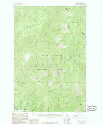
1985 Map of Murray
USGS Topo · Published 1985About this map
Prichard lies at the southern edge of this map, situated near the confluence of Murray Creek and the North Fork Coeur d'Alene River. The landscape is defined by the legacy of mineral extraction, evidenced by the extensive Dredge Tailings along the valley floor. High ridges such as Bobtail Ridge and peaks including Murray Peak and Maple Peak create a complex network of drainages including Gold Run and West Fork Eagle Creek.
Find a feature on this map
51 named features on this map. Tap any name to fly to it.
Don’t see what you’re looking for? This feature index may not catch every label — zoom into the map to look around manually.
Map Details
Editions of this 1985 Murray Map
This is the sole edition of this map. No revisions or reprints were ever made.
Other maps of this area

1901 · Coeur D'Alene District
USGS Topo · 1:62,500

1903 · Coeur D'Alene District
USGS Topo · 1:62,500

1906 · Coeur D'Alene District
USGS Topo · 1:62,500

1932 · Trout Creek
USGS Topo · 1:125,000

1935 · Trout Creek
USGS Topo · 1:125,000

1936 · Trout Creek
USGS Topo · 1:125,000

1956 · Cooper Gulch
USGS Topo · 1:62,500

1956 · Wallace
USGS Topo · 1:250,000

1957 · Burke
USGS Topo · 1:62,500

1960 · Wallace
USGS Topo · 1:250,000