
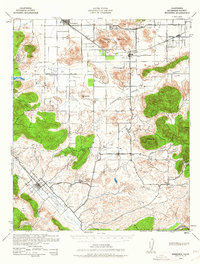
1942 Map of Murrieta
USGS Topo · Published 1958About this map
Murrieta Hot Springs sits at the heart of this Southern California landscape, a region defined during the early war years by expansive valleys and isolated homesteads. The Atchison Topeka and Santa Fe railroad cuts across the northern terrain through Winchester and Romoland, while the road network connects rural schoolhouses like the Menifee Sch and Antelope Sch. The landscape is a series of distinct basins, including Menifee Valley and Domenigoni Valley, where small mining operations like the Leon Mine once operated. This survey reveals the area before modern suburban development, showing the original drainage patterns of Murrieta Creek and the scattered agricultural character of settlements like Linda Rose and Glenoak. Natural features such as Bachelor Mtn and Double Butte serve as prominent landmarks overlooking the canyons and mesas that once supported a quiet ranching and mining economy.
Find a feature on this map
52 named features on this map. Tap any name to fly to it.
Don’t see what you’re looking for? This feature index may not catch every label — zoom into the map to look around manually.
Map Details
Editions of this 1942 Murrieta Map
2 editions found
Other maps of this area

1901 · Southern California Sheet No. 1
USGS Topo · 1:250,000

1901 · San Jacinto
USGS Topo · 1:125,000

1901 · Elsinore
USGS Topo · 1:125,000

1901 · San Luis Rey
USGS Topo · 1:125,000

1901 · Riverside
USGS Topo · 1:62,500

1903 · Ramona
USGS Topo · 1:125,000

1904 · Southern California Sheet No. 2
USGS Topo · 1:250,000

1904 · Southern California Sheet No. 1
USGS Topo · 1:250,000

1939 · Palomar Mountain
USGS Topo · 1:62,500

1941 · Margarita Peak
USGS Topo · 1:62,500