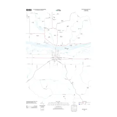
2013 Map of Muscoda
USGS Topo · Published 2013About this map
The Wisconsin River dominates this region, carved with complex channels and islands including McClary Island and the uniquely named Muscoda Island High Bank Island. On the southern bank, the village of Muscoda serves as a central hub, flanked by the residential Evergreen Terrace and surrounded by a landscape defined by generational family agriculture. The map identifies numerous named operations such as Valley Brook Holstein Farm, South Mill Creek Holstein Farm, and Eckstein Stock and Grain Farm, reflecting the area's deep-rooted dairy and grain heritage. To the north, the small settlement of Orion sits near the river's edge, while the terrain transitions into features like Bomkamp Ridge and Miller Hollow. This survey provides a clear view of the rural road network, including Wi-80 and Wi-60, connecting the scattered farms and homesteads that have sustained this riverfront community for decades.
Find a feature on this map
108 named features on this map. Tap any name to fly to it.
Don’t see what you’re looking for? This feature index may not catch every label — zoom into the map to look around manually.
Map Details
Editions of this 2013 Muscoda Map
This is the sole edition of this map. No revisions or reprints were ever made.
Other maps of this area

1905 · Richland Center
USGS Topo · 1:125,000

1933 · Boaz
USGS Topo · 1:62,500

1933 · Boscobel
USGS Topo · 1:62,500

1958 · La Crosse
USGS Topo · 1:250,000

1960 · Richland Center
USGS Topo · 1:62,500

1960 · Muscoda
USGS Topo · 1:62,500

1961 · La Crosse
USGS Topo · 1:250,000

1965 · La Crosse
USGS Topo · 1:250,000

1966 · Boaz
USGS Topo · 1:62,500
1967 · Boscobel
USGS Topo · 1:62,500