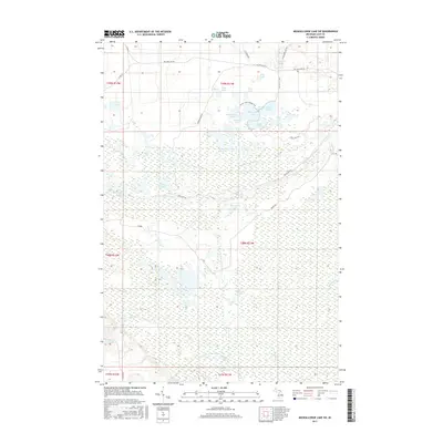
2017 Map of Muskallonge Lake SW
USGS Topo · Published 2017About this map
The northern reaches of Luce County are defined here by the complex, branching hydrology of the Two Hearted River system. Three primary forks converge within this wilderness landscape, including the W Br Two Hearted River, the N Br Two Hearted River, and the S Br Two Hearted River. The terrain is densely packed with glacial kettle lakes, particularly in the northern sections where clusters like Beaverhouse Lake, Camp Eight Lake, and Pretty Lake are interconnected by the Pretty Lakes Hiking Trail. The presence of naming conventions such as Poplar Camp Rd and Ohio Camp Rd suggests a history of remote seasonal encampments or logging sites. Further south, the landscape shifts toward lower wetland drainages like Jack Lake and Little Whorl Lake, illustrating the transition from lake-strewn highlands to riverine marshes.
Find a feature on this map
51 named features on this map. Tap any name to fly to it.
Don’t see what you’re looking for? This feature index may not catch every label — zoom into the map to look around manually.
Map Details
Editions of this 2017 Muskallonge Lake SW Map
This is the sole edition of this map. No revisions or reprints were ever made.
Other maps of this area

1954 · Sault Sainte Marie
USGS Topo · 1:250,000

1956 · Sault Sainte Marie
USGS Topo · 1:250,000

1957 · Sault Sainte Marie
USGS Topo · 1:250,000

1958 · Sault Sainte Marie
USGS Topo · 1:250,000

1962 · Auger Lake
USGS Topo · 1:24,000

1968 · Muskallonge Lake East
USGS Topo · 1:24,000

1968 · Muskallonge Lake SW
USGS Topo · 1:24,000

1968 · Muskallonge Lake West
USGS Topo · 1:24,000

1968 · Muskallonge Lake SE
USGS Topo · 1:24,000
1968 · Grand Marais SE
USGS Topo · 1:24,000