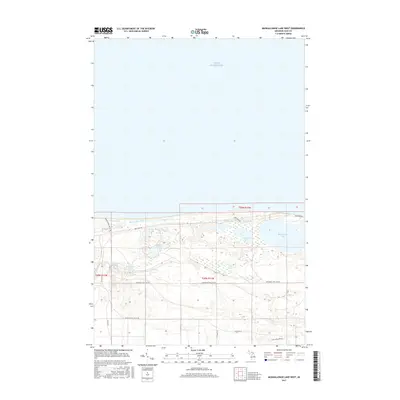
2017 Map of Muskallonge Lake West
USGS Topo · Published 2017About this map
Lake Superior dominates the northern expanse of this Luce County coastline, where the landscape is defined by a dense network of inland water bodies and forest access routes. The eastern edge of the map features Muskallonge Lake, a prominent coastal lake separated from the Great Lake by a narrow strip of land traversed by Deer Park Rd. Moving west, the Blind Sucker River meanders parallel to the shore, fed by a series of smaller lakes and wetlands including Rainy Lake, Ready Lakes, and Snowplow Lake. This Upper Peninsula terrain is heavily marked by late-century forestry and fire management infrastructure, evidenced by the prevalence of specialized routes such as the Grand Marais Truck Trl and Sevenmile Fire Lane Rd. The map illustrates a transitional landscape where water and woodland meet, offering a detailed view of the hydrology between the river system and the Superior shoreline.
Find a feature on this map
22 named features on this map. Tap any name to fly to it.
Don’t see what you’re looking for? This feature index may not catch every label — zoom into the map to look around manually.
Map Details
Editions of this 2017 Muskallonge Lake West Map
This is the sole edition of this map. No revisions or reprints were ever made.
Other maps of this area

1954 · Sault Sainte Marie
USGS Topo · 1:250,000

1956 · Sault Sainte Marie
USGS Topo · 1:250,000

1957 · Sault Sainte Marie
USGS Topo · 1:250,000

1958 · Sault Sainte Marie
USGS Topo · 1:250,000

1968 · Muskallonge Lake East
USGS Topo · 1:24,000

1968 · Muskallonge Lake SW
USGS Topo · 1:24,000

1968 · Muskallonge Lake West
USGS Topo · 1:24,000

1968 · Muskallonge Lake SE
USGS Topo · 1:24,000
1968 · Grand Marais SE
USGS Topo · 1:24,000
1968 · Grand Marais NE
USGS Topo · 1:24,000