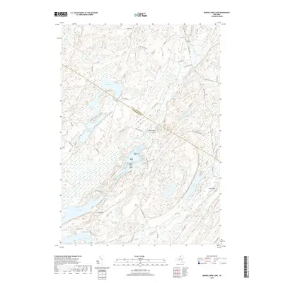
2019 Map of Muskellunge Lake
USGS Topo · Published 2019About this map
Honey Hill and the surrounding woodlands on the border of Jefferson and St. Lawrence Counties define this landscape, where the Indian River winds through a complex series of glacial lakes and wetlands. The area is characterized by significant water bodies including Lake of the Woods, Muskellunge Lake, and Moon Lake, many of which feature intricate shorelines with named points like Elephants Foot and Big Island. Local history is anchored by the presence of Riverside Cem and Saint Patricks Cem in the northern section of the quadrangle. The naming of Lead Mine Rd suggests the historical importance of mineral extraction in this part of New York, while the network of unpaved roads and connectors like Scotch Settlement Rd and Old Meacham Rd indicates a rural settlement pattern that follows the natural contours of the river valleys and rocky outcrops such as Pulpit Rock.
Find a feature on this map
70 named features on this map. Tap any name to fly to it.
Don’t see what you’re looking for? This feature index may not catch every label — zoom into the map to look around manually.
Map Details
Editions of this 2019 Muskellunge Lake Map
This is the sole edition of this map. No revisions or reprints were ever made.
Other maps of this area

1903 · Alexandria Bay
USGS Topo · 1:62,500

1903 · Theresa
USGS Topo · 1:62,500

1911 · Antwerp
USGS Topo · 1:62,500

1912 · Hammond
USGS Topo · 1:62,500

1943 · Redwood
USGS Topo · 1:31,680

1944 · Hammond
USGS Topo · 1:62,500

1948 · Theresa
USGS Topo · 1:24,000

1948 · Chippewa Bay
USGS Topo · 1:24,000
1948 · Theresa
USGS Topo · 1:62,500

1948 · Alexandria Bay
USGS Topo · 1:62,500