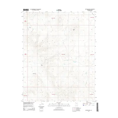
2014 Map of Mustang Knoll
USGS Topo · Published 2014About this map
Mustang Knoll stands as the central landmark in this high-desert landscape of Mohave County, where the scarcity of water has long dictated the patterns of human and animal movement. The terrain is etched with deep drainage features like Road Canyon and Hobble Canyon, while the life of the region is centered around isolated water sources. From the naturally occurring Alkaline Seep and Mustang Spring to man-made catchments like the Stock Driveway Reservoir, these points reveal the infrastructure of western ranching. In the northwest, the map documents a cluster of resources within Ide Valley, including Ide Valley Spring and Hidden Valley Spring. The network of simple tracks and remote water tanks, such as Imlay Resort Tank, illustrates the persistent utility of this arid country for grazing and transit in the modern era.
Find a feature on this map
23 named features on this map. Tap any name to fly to it.
Don’t see what you’re looking for? This feature index may not catch every label — zoom into the map to look around manually.
Map Details
Editions of this 2014 Mustang Knoll Map
This is the sole edition of this map. No revisions or reprints were ever made.
Other maps of this area

1886 · Mt. Trumbull
USGS Topo · 1:250,000

1892 · Mt. Trumbull
USGS Topo · 1:250,000

1953 · Grand Canyon
USGS Topo · 1:250,000

1954 · Littlefield 3 NE
USGS Topo · 1:24,000
1954 · Littlefield 3 SE
USGS Topo · 1:24,000

1954 · Littlefield
USGS Topo · 1:62,500

1954 · Cane Springs
USGS Topo · 1:62,500

1957 · Grand Canyon
USGS Topo · 1:250,000

1958 · Grand Canyon
USGS Topo · 1:250,000

1960 · Grand Canyon
USGS Topo · 1:250,000