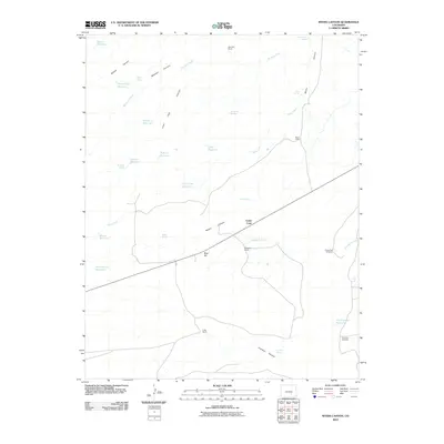
2010 Map of Myers Canyon
USGS Topo · Published 2010About this map
Myers Canyon and the high plains of southern Colorado define this landscape as it appeared in the early 21st century. The map reveals an arid terrain managed through a complex network of small-scale water storage, including the Mayer Reservoir, Prairie Dog Reservoir, and Federal Reservoir. Ranching operations such as the Spurlock Ranch and Knowlton Ranch are scattered across the quadrangle, connected by State Route 10, which traverses the center from Blue Hill through Cedar Crest. The presence of features like Railroad Fill Reservoir suggests the historical influence of transportation infrastructure on water management in this dry environment. Local geography is further marked by numerous named springs like Cottonwood Spring and Myers Spring, which served as vital resources for livestock and early settlements in the Robins Canyon and Averson Canyon regions.
Find a feature on this map
35 named features on this map. Tap any name to fly to it.
Don’t see what you’re looking for? This feature index may not catch every label — zoom into the map to look around manually.
Map Details
Editions of this 2010 Myers Canyon Map
This is the sole edition of this map. No revisions or reprints were ever made.
Other maps of this area

1891 · Apishapa
USGS Topo · 1:125,000

1893 · Apishapa
USGS Topo · 1:125,000

1897 · Apishapa
USGS Topo · 1:125,000

1954 · Trinidad
USGS Topo · 1:250,000

1955 · Trinidad
USGS Topo · 1:250,000

1958 · Trinidad
USGS Topo · 1:250,000

1959 · Trinidad
USGS Topo · 1:250,000
1970 · Hog Ranch Canyon
USGS Topo · 1:24,000
1970 · Red Top Ranch
USGS Topo · 1:24,000
1970 · Yellowbank Creek
USGS Topo · 1:24,000