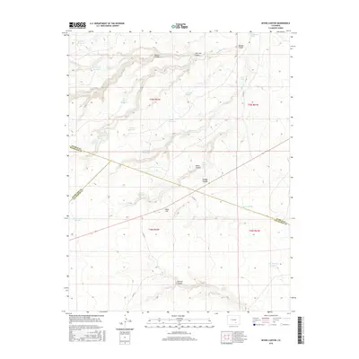
2016 Map of Myers Canyon
USGS Topo · Published 2016About this map
Cedar Crest serves as the central hub of this high-plains landscape, situated where the borders of Pueblo, Huerfano, and Las Animas counties converge. The terrain is defined by a dense network of water management features, including Log House Reservoir, Mayer Reservoir, and Railroad Fill Reservoir, indicating a landscape deeply tied to ranching or resource extraction requirements. Drainage patterns such as Plum Cr and Saunders Arroyo cut through the elevation, which rises toward landmarks like Blue Hill. The numerous springs, including Whiskey Spring and Oscar Spring, suggest a reliance on these isolated water sources for livestock or early settlement in a region marked by deep cuts like Madden Canyon and Lone Jack Canyon. This 2016 survey captures the persistent rural character of the Colorado borderlands.
Find a feature on this map
37 named features on this map. Tap any name to fly to it.
Don’t see what you’re looking for? This feature index may not catch every label — zoom into the map to look around manually.
Map Details
Editions of this 2016 Myers Canyon Map
This is the sole edition of this map. No revisions or reprints were ever made.
Other maps of this area

1891 · Apishapa
USGS Topo · 1:125,000

1893 · Apishapa
USGS Topo · 1:125,000

1897 · Apishapa
USGS Topo · 1:125,000

1954 · Trinidad
USGS Topo · 1:250,000

1955 · Trinidad
USGS Topo · 1:250,000

1958 · Trinidad
USGS Topo · 1:250,000

1959 · Trinidad
USGS Topo · 1:250,000
1970 · Hog Ranch Canyon
USGS Topo · 1:24,000
1970 · Red Top Ranch
USGS Topo · 1:24,000
1970 · Yellowbank Creek
USGS Topo · 1:24,000