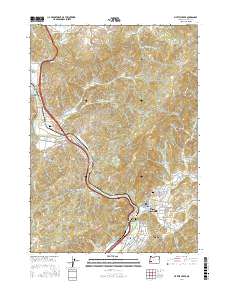
2017 Map of Myrtle Creek
USGS Topo · Published 2017About this map
The South Umpqua River carves a winding path through this Douglas County landscape, anchoring the developed corridor of Myrtle Creek and Tri-City. This 2017 survey details the complex terrain where the river meets Missouri Bottom and is flanked by prominent elevations like Roberts Mtn and Gobblers Knob. For genealogists and local historians, the map serves as a precise guide to several burial sites, including the Myrtle Creek Pioneer Cem and the Myrtle Creek IOOF Cem, as well as the Burnett Cem near Round Prairie. The map also captures the area's timber industry legacy, specifically naming the Engles and Worth Log Pond. Transport infrastructure is well-defined, from the Neal Lane Bridge to the network of ridge roads like Bilger Ridge Spr that penetrate the high country east of the river valley.
Find a feature on this map
86 named features on this map. Tap any name to fly to it.
Don’t see what you’re looking for? This feature index may not catch every label — zoom into the map to look around manually.
Map Details
Editions of this 2017 Myrtle Creek Map
This is the sole edition of this map. No revisions or reprints were ever made.
Other maps of this area

1897 · Roseburg
USGS Topo · 1:125,000

1900 · Roseburg
USGS Topo · 1:125,000

1904 · Riddle
USGS Topo · 1:125,000

1954 · Dixonville
USGS Topo · 1:62,500

1954 · Days Creek
USGS Topo · 1:62,500

1954 · Canyonville
USGS Topo · 1:62,500

1955 · Roseburg
USGS Topo · 1:62,500

1955 · Medford
USGS Topo · 1:250,000

1957 · Medford
USGS Topo · 1:250,000

1958 · Medford
USGS Topo · 1:250,000