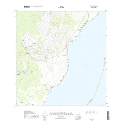
2017 Map of Naalehu
USGS Topo · Published 2017About this map
The southern shoreline of the Island of Hawaii is defined here by dramatic coastal cliffs and scattered agricultural settlements. From the residential streets of Discovery Harbour to the historic hub of Naalehu, the landscape reflects a transition from high volcanic slopes to the Pacific. Inland, terrain features like Waiaele Gulch and Alapa‘i Gulch carve through the landscape, while fresh water sources like Portuguese Springs and Haao Springs provided essential resources for early ranching and habitation. The coastline is marked by significant cultural and geological landmarks, including the Ala Kahakai National Historic Trail which traverses past sites like Kahua Olohu and the steep precipices of Māniania Pali. This modern survey documents the continued use of local aviation at Kaalaiki Airstrip alongside traditional place names that have anchored the region for generations.
Find a feature on this map
70 named features on this map. Tap any name to fly to it.
Don’t see what you’re looking for? This feature index may not catch every label — zoom into the map to look around manually.
Map Details
Editions of this 2017 Naalehu Map
This is the sole edition of this map. No revisions or reprints were ever made.
Other maps of this area

1923 · Pahala
USGS Topo · 1:62,500

1924 · Kalae
USGS Topo · 1:62,500

1924 · Honuapo
USGS Topo · 1:62,500

1954 · Hawaii South
USGS Topo · 1:250,000

1959 · Hawaii South
USGS Topo · 1:250,000

1961 · Hawaii South
USGS Topo · 1:250,000

1962 · Hawaii South
USGS Topo · 1:250,000

1962 · Kahuku Ranch
USGS Topo · 1:24,000
1962 · Ka Lae
USGS Topo · 1:24,000
1962 · Naalehu
USGS Topo · 1:24,000