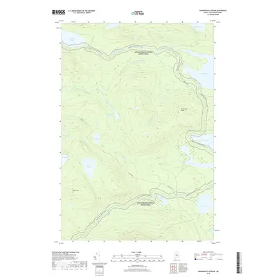
2018 Map of Nahmakanta Stream
USGS Topo · Published 2018About this map
The Appalachian National Scenic Trail winds through the heart of this Piscataquis County landscape, following a route that skirts Nahmakanta Stream and climbs the slopes above Jo-Mary Lake. This interior Maine region is defined by its complex network of water bodies, from the expansive Nahmakanta Lake and Pemadumcook Lake to smaller, isolated features like Church Pond and Rabbit Pond. High ground is marked by Potaywadjo Ridge and Cooper Mtn, offering a view of the intricate drainage patterns that feed into the larger lakes. Access to these backwoods is limited to a few arterial routes such as Jo Mary Rd and the T1R10 Access Rd, highlighting the remote and largely undeveloped character of the Maine woods during this era.
Find a feature on this map
26 named features on this map. Tap any name to fly to it.
Don’t see what you’re looking for? This feature index may not catch every label — zoom into the map to look around manually.
Map Details
Editions of this 2018 Nahmakanta Stream Map
This is the sole edition of this map. No revisions or reprints were ever made.
Other maps of this area

1927 · Katahdin
USGS Topo · 1:48,000

1930 · Katahdin
USGS Topo · 1:62,500

1949 · Katahdin
USGS Topo · 1:62,500

1951 · Norcross
USGS Topo · 1:62,500

1952 · Jo-Mary Mountain
USGS Topo · 1:62,500

1954 · Harrington Lake
USGS Topo · 1:62,500

1954 · Millinocket
USGS Topo · 1:250,000

1958 · Millinocket
USGS Topo · 1:250,000

1960 · Millinocket
USGS Topo · 1:250,000
1978 · Rainbow Lake West
USGS Topo · 1:24,000