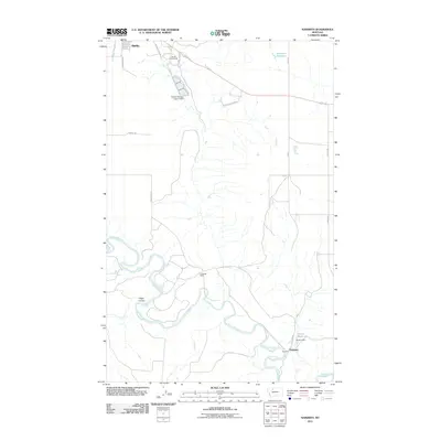
2011 Map of Naismith
USGS Topo · Published 2011About this map
The winding Marias River carves a deep, serpentine path through this section of the Montana plains, defining the topography south of Shelby. This 2011 survey illustrates a transition from the urban edge of the county seat to the agricultural and ranching corridors along the river valley. Landmarks like the Marias Fairground and Shelby Sewage Lagoon Dam sit near the northern boundary, while the small settlement of Naismith anchors the southeast corner near Ovens Reservoir and Ovens Dam. The landscape is primarily organized by a grid of rural routes, including Underdahl Rd and S Kraft, which serve isolated sites such as the Underdal Ranch. Local drainage features like Hilger Coulee feed into the river system, which remains the most prominent natural feature across the quadrangle.
Find a feature on this map
21 named features on this map. Tap any name to fly to it.
Don’t see what you’re looking for? This feature index may not catch every label — zoom into the map to look around manually.
Map Details
Editions of this 2011 Naismith Map
This is the sole edition of this map. No revisions or reprints were ever made.
Other maps of this area

1920 · Conrad
USGS Topo · 1:125,000

1943 · Antelope Coulee
USGS Topo · 1:62,500

1943 · Shelby
USGS Topo · 1:62,500

1954 · Shelby
USGS Topo · 1:250,000

1958 · Shelby
USGS Topo · 1:250,000

1967 · Naismith
USGS Topo · 1:24,000

1967 · Conrad Butte
USGS Topo · 1:24,000

1967 · Dunkirk
USGS Topo · 1:24,000
1967 · Pioneer School
USGS Topo · 1:24,000
1967 · Ledger NW
USGS Topo · 1:24,000