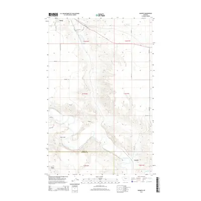
2014 Map of Naismith
USGS Topo · Published 2014About this map
Shelby anchors the northwestern corner of this High Plains landscape, where the agricultural plateaus of Toole Co meet the northern edge of Pondera Co. The terrain is defined by the winding course of the Marias River as it carves through the southern portion of the quadrangle, creating a complex system of drainage features like Hilger Coulee and Pearson Coulee. The map reveals a highly structured grid of section lines and rural infrastructure, including water management sites such as Summers Reservoir and Ovens Reservoir that support the region's ranching and farming operations.
Find a feature on this map
33 named features on this map. Tap any name to fly to it.
Don’t see what you’re looking for? This feature index may not catch every label — zoom into the map to look around manually.
Map Details
Editions of this 2014 Naismith Map
This is the sole edition of this map. No revisions or reprints were ever made.
Other maps of this area

1920 · Conrad
USGS Topo · 1:125,000

1943 · Antelope Coulee
USGS Topo · 1:62,500

1943 · Shelby
USGS Topo · 1:62,500

1954 · Shelby
USGS Topo · 1:250,000

1958 · Shelby
USGS Topo · 1:250,000

1967 · Naismith
USGS Topo · 1:24,000

1967 · Conrad Butte
USGS Topo · 1:24,000

1967 · Dunkirk
USGS Topo · 1:24,000
1967 · Pioneer School
USGS Topo · 1:24,000
1967 · Ledger NW
USGS Topo · 1:24,000