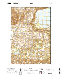
2019 Map of Naknek B-1 NE
USGS Topo · Published 2019About this map
Katmai National Park encompasses the majority of this landscape in the Lake and Peninsula Borough. The terrain is defined by the vast waters of Lake Brooks in the northeast and a complex network of wetlands and drainage patterns that characterize this portion of the Alaska Peninsula. This 2019 survey, utilizing 2009 SPOT imagery and National Hydrography Dataset records, illustrates the preserved wilderness and hydrological systems within the federal park boundaries. The absence of roads or permanent settlements highlights the protected status of the area, where the environment remains shaped by natural processes rather than human development.
Find a feature on this map
8 named features on this map. Tap any name to fly to it.
Don’t see what you’re looking for? This feature index may not catch every label — zoom into the map to look around manually.
Map Details
Editions of this 2019 Naknek B-1 NE Map
This is the sole edition of this map. No revisions or reprints were ever made.
Other maps of this area

1948 · Mt Katmai
USGS Topo · 1:250,000

1951 · Mt Katmai
USGS Topo · 1:250,000

1951 · Mount Katmai C-6
USGS Topo · 1:63,360

1951 · Mount Katmai B-6
USGS Topo · 1:63,360

1951 · Naknek B-1
USGS Topo · 1:63,360

1951 · Naknek C-1
USGS Topo · 1:63,360

1952 · Naknek
USGS Topo · 1:250,000
1953 · Mt. Katmai B-6
USGS Topo · 1:63,360

1964 · Mt. Katmai
USGS Topo · 1:250,000

1964 · Naknek
USGS Topo · 1:250,000