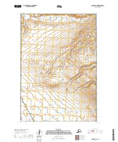
2019 Map of Naknek B-1 SE
USGS Topo · Published 2019About this map
The vast, undeveloped landscape of the Alaska Peninsula is represented here at the intersection of two major federal conservation areas. Katmai National Park dominates the northern and central sections of the quadrangle, where the terrain climbs steadily into high-elevation contours. To the south, the boundary of the Becharof National Wildlife Refuge marks a transition into the tundra and wetlands characteristic of this subarctic coastal region. The map illustrates a complete absence of permanent human infrastructure, roads, or named settlements, reflecting the primitive wilderness state preserved by these designations in the early 21st century. Instead, the document focuses on the complex topography and hydrological patterns of the Bristol Bay watershed, providing a detailed look at the drainage systems within T21S R42W and adjacent townships.
Find a feature on this map
6 named features on this map. Tap any name to fly to it.
Don’t see what you’re looking for? This feature index may not catch every label — zoom into the map to look around manually.
Map Details
Editions of this 2019 Naknek B-1 SE Map
This is the sole edition of this map. No revisions or reprints were ever made.
Other maps of this area

1948 · Mt Katmai
USGS Topo · 1:250,000

1951 · Mt Katmai
USGS Topo · 1:250,000

1951 · Mount Katmai A-6
USGS Topo · 1:63,360

1951 · Mount Katmai B-6
USGS Topo · 1:63,360

1951 · Naknek B-1
USGS Topo · 1:63,360

1951 · Naknek A-1
USGS Topo · 1:63,360

1952 · Naknek
USGS Topo · 1:250,000
1953 · Mt. Katmai B-6
USGS Topo · 1:63,360

1964 · Mt. Katmai
USGS Topo · 1:250,000

1964 · Naknek
USGS Topo · 1:250,000