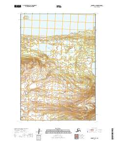
2019 Map of Naknek C-1 SE
USGS Topo · Published 2019About this map
Naknek Lake borders the northern edge of this territory, where the water meets a landscape defined by the expansive protected wilderness of Katmai National Park. The terrain reflects a complex system of glacial and volcanic influence, evidenced by the intricate contour patterns that rise from the lakeshore into the upland areas. This 2019 survey documents the southeastern portion of the Naknek C-1 quadrangle, a region largely absent of modern development or road networks. Instead, the map focuses on the pristine natural features and the established boundaries of the national park, providing a clear record of the area's topographical character for conservationists and wilderness researchers studying the Katmai National Park interior.
Find a feature on this map
6 named features on this map. Tap any name to fly to it.
Don’t see what you’re looking for? This feature index may not catch every label — zoom into the map to look around manually.
Map Details
Editions of this 2019 Naknek C-1 SE Map
This is the sole edition of this map. No revisions or reprints were ever made.
Other maps of this area

1948 · Mt Katmai
USGS Topo · 1:250,000

1951 · Mt Katmai
USGS Topo · 1:250,000

1951 · Mount Katmai C-6
USGS Topo · 1:63,360

1951 · Mount Katmai B-6
USGS Topo · 1:63,360

1951 · Naknek B-1
USGS Topo · 1:63,360

1951 · Naknek C-1
USGS Topo · 1:63,360

1952 · Naknek
USGS Topo · 1:250,000
1953 · Mt. Katmai B-6
USGS Topo · 1:63,360

1964 · Mt. Katmai
USGS Topo · 1:250,000

1964 · Naknek
USGS Topo · 1:250,000