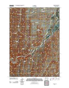
2011 Map of Namorf
USGS Topo · Published 2011About this map
The Malheur River cuts a prominent path through this high desert region of Eastern Oregon, defining the settlement and infrastructure patterns of the early 21st century. Along its banks lies Namorf, a namesake location tied to the area's transit corridor. The surrounding landscape is heavily modified by a network of water management features, including Hollow Reservoir, Chicken Creek Reservoir, and Lower Black Canyon Reservoir, which reflect the essential role of irrigation and livestock watering in this arid environment.
Find a feature on this map
30 named features on this map. Tap any name to fly to it.
Don’t see what you’re looking for? This feature index may not catch every label — zoom into the map to look around manually.
Map Details
Editions of this 2011 Namorf Map
This is the sole edition of this map. No revisions or reprints were ever made.
Other maps of this area

1955 · Boise
USGS Topo · 1:250,000

1958 · Boise
USGS Topo · 1:250,000

1962 · Boise
USGS Topo · 1:250,000

1966 · Harper
USGS Topo · 1:62,500

1966 · Westfall Butte
USGS Topo · 1:62,500

1972 · Tims Peak
USGS Topo · 1:24,000

1972 · Avery Creek
USGS Topo · 1:24,000
1972 · Keeney Ridge
USGS Topo · 1:24,000
1990 · South Mountain
USGS Topo · 1:24,000
1990 · Westfall
USGS Topo · 1:24,000