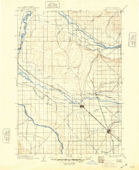
1898 Map of Nampa
USGS Topo · Published 1948About this map
The confluence of the Boise River and the Snake River defines this late 19th-century landscape at the Idaho-Oregon border. Surveyed in 1891, the region is shaped by the expansion of the Oregon Short Line and an intricate network of irrigation projects essential for Western settlement. The engineering of the high desert is evident in the numerous waterways such as the Phyllis Canal, Reed Canal, and the Middleton Water Co. Canal, which redirected water to support burgeoning farming communities. Early townsites like Caldwell and Nampa appear as established rail hubs, while smaller outposts like Falks Store and Lemp dot the river valleys. The map also records the prominent Deer Flat region before it was transformed by later reclamation projects, and tracks the Boise Nampa & Owyhee R. R. heading south toward the mines.
Find a feature on this map
57 named features on this map. Tap any name to fly to it.
Don’t see what you’re looking for? This feature index may not catch every label — zoom into the map to look around manually.
Map Details
Editions of this 1898 Nampa Map
4 editions found
Other maps of this area

1892 · Boise
USGS Topo · 1:125,000

1892 · Bisuka
USGS Topo · 1:125,000

1892 · Silver City
USGS Topo · 1:125,000

1894 · Bisuka
USGS Topo · 1:125,000

1894 · Silver City
USGS Topo · 1:125,000

1894 · Squaw Creek
USGS Topo · 1:125,000

1897 · Boise
USGS Topo · 1:125,000

1897 · Weiser
USGS Topo · 1:125,000

1898 · Nampa
USGS Topo · 1:125,000

1898 · Silver City
USGS Topo · 1:125,000