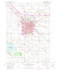
1958 Map of Nampa
USGS Topo · Published 1981About this map
The Union Pacific rail lines and the Pacific Highway define the transit-driven core of Nampa in this mid-century survey. Irrigation infrastructure, vital to this region of Idaho, is represented by a complex network of waterways including the Phyllis Canal, New York Canal, and Ridenbaugh Canal. These canals transformed the arid Deer Flat landscape into productive agricultural land, supporting local industry like the Sugar Factory and its associated Sugar Factory Camp. Educational and social institutions are well-established, from the campus of Northwest Nazarene College to the Nampa State School. To the southwest, the Deer Flat National Wildlife Refuge borders the expanse of Lake Lowell, providing a sharp contrast between the burgeoning urban core of Nampa and the protected natural environment of Gull Island. Smaller communities and junctions like Karcher Junction, Fischer, and Moss surround the city, while numerous local schools such as Sunny Ridge School and Greenhurst School anchor the outlying rural neighborhoods.
Find a feature on this map
99 named features on this map. Tap any name to fly to it.
Don’t see what you’re looking for? This feature index may not catch every label — zoom into the map to look around manually.
Map Details
Editions of this 1958 Nampa Map
4 editions found
Other maps of this area

1892 · Boise
USGS Topo · 1:125,000

1892 · Bisuka
USGS Topo · 1:125,000

1892 · Silver City
USGS Topo · 1:125,000

1894 · Bisuka
USGS Topo · 1:125,000

1894 · Silver City
USGS Topo · 1:125,000

1897 · Boise
USGS Topo · 1:125,000

1898 · Nampa
USGS Topo · 1:125,000

1898 · Silver City
USGS Topo · 1:125,000

1953 · Meridian
USGS Topo · 1:24,000

1953 · Star
USGS Topo · 1:24,000