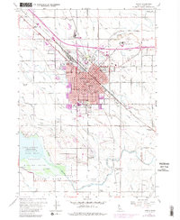
1958 Map of Nampa
USGS Topo · Published 1981About this map
Agricultural and industrial growth define Nampa during the late 1950s, a period when the city was evolving as a regional hub for processing and education. The Sugar Factory and its nearby Sugar Factory Camp highlight the area's economic reliance on the surrounding farmland, which is irrigated by an extensive network including the New York Canal and Ridenbaugh Canal. This map captures the campus of Northwest Nazarene College and numerous local institutions like the Nampa State School and Mt Calvary Cemetery. Beyond the urban core, rural life is marked by named intersections such as Kings Corner and Tiegs Corner, along with dozens of local schools including Lone Star School and Sunny Ridge School. To the southwest, the vast waters of Lake Lowell and the Deer Flat National Wildlife Refuge provide a stark contrast to the busy Union Pacific rail lines cutting through the center of town.
Find a feature on this map
62 named features on this map. Tap any name to fly to it.
Don’t see what you’re looking for? This feature index may not catch every label — zoom into the map to look around manually.
Map Details
Editions of this 1958 Nampa Map
4 editions found
Other maps of this area

1892 · Boise
USGS Topo · 1:125,000

1892 · Bisuka
USGS Topo · 1:125,000

1892 · Silver City
USGS Topo · 1:125,000

1894 · Bisuka
USGS Topo · 1:125,000

1894 · Silver City
USGS Topo · 1:125,000

1897 · Boise
USGS Topo · 1:125,000

1898 · Nampa
USGS Topo · 1:125,000

1898 · Silver City
USGS Topo · 1:125,000

1953 · Meridian
USGS Topo · 1:24,000

1953 · Star
USGS Topo · 1:24,000