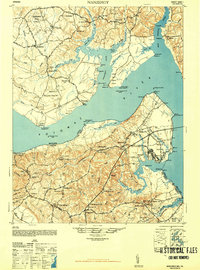
1948 Map of Nanjemoy
USGS Topo · Published 1948About this map
The Potomac River bisects this mid-century landscape, separating the rural tobacco lands of Maryland from the emerging military presence in Virginia. On the Virginia shore, the U S Naval Proving Ground dominates the peninsula, centered around Dahlgren and the coastal defenses near Machadoc Creek. This region shows a transition from a traditional agrarian economy to one influenced by federal infrastructure, evidenced by the proximity of established county seats like King George to modern naval installations.
Find a feature on this map
91 named features on this map. Tap any name to fly to it.
Don’t see what you’re looking for? This feature index may not catch every label — zoom into the map to look around manually.
Map Details
Editions of this 1948 Nanjemoy Map
2 editions found
Other maps of this area

1889 · Fredericksburg
USGS Topo · 1:125,000

1890 · Mt. Vernon
USGS Topo · 1:125,000

1891 · Mt. Vernon
USGS Topo · 1:125,000

1892 · Fredericksburg
USGS Topo · 1:125,000

1892 · Brandywine
USGS Topo · 1:62,500

1892 · Montross
USGS Topo · 1:62,500

1894 · Wicomico
USGS Topo · 1:62,500

1894 · Fredericksburg
USGS Topo · 1:125,000

1894 · Mt. Vernon
USGS Topo · 1:125,000

1895 · Wicomico
USGS Topo · 1:62,500