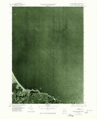
1977 Map of Nantasket Beach
USGS Topo · Published 1980About this map
Massachusetts Bay dominates this orthophotoquad, captured via aerial photography in the spring of 1977. This hybrid document combines the visual precision of photography with topographic labeling, revealing the fine-grained coastal density of North Cohasset and the narrow, sandy reach of Nantasket Beach. Unlike a standard line-map, this imagery highlights the specific texture of the built environment and the exact shoreline of Straits Pond. The transition from the tidal influence of the Weir River to the open Atlantic water provides a clear record of the region's land use and shoreline management during the late 1970s, serving as a critical reference for understanding the physical development of this South Shore landscape before more modern coastal shifts.
Find a feature on this map
5 named features on this map. Tap any name to fly to it.
Don’t see what you’re looking for? This feature index may not catch every label — zoom into the map to look around manually.
Map Details
Editions of this 1977 Nantasket Beach Map
This is the sole edition of this map. No revisions or reprints were ever made.
Other maps of this area

1885 · Abington
USGS Topo · 1:62,500

1885 · Duxbury
USGS Topo · 1:62,500

1888 · Duxbury
USGS Topo · 1:62,500

1888 · Abington
USGS Topo · 1:62,500

1892 · Boston Bay
USGS Topo · 1:62,500

1893 · Abington
USGS Topo · 1:62,500

1893 · Duxbury
USGS Topo · 1:62,500

1903 · Boston Bay
USGS Topo · 1:62,500

1918 · Duxbury
USGS Topo · 1:62,500

1920 · Abington
USGS Topo · 1:62,500