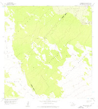
1956 Map of Naohueleelua
USGS Topo · Published 1976About this map
The Mauna Loa Forest and Game Reserve dominates this 1950s landscape, illustrating the complex volcanic terrain on the island of Hawaii. The map vividly captures the path of the Lava Flow of 1859, which cuts across the western portion of the quadrangle, bordering the Puuanahulu and Keauhou 2 regions. This survey highlights the survival of older vegetation and soil, known as kipukas, including Kipuka Kalawamauna and Kipuka Alala, which appear as islands of greenery surrounded by more recent flows.
Find a feature on this map
17 named features on this map. Tap any name to fly to it.
Don’t see what you’re looking for? This feature index may not catch every label — zoom into the map to look around manually.
Map Details
Editions of this 1956 Naohueleelua Map
2 editions found

Other maps of this area

1927 · Kaohe
USGS Topo · 1:62,500

1928 · Puako
USGS Topo · 1:62,500

1928 · Kailua
USGS Topo · 1:62,500

1930 · Kaohe
USGS Topo · 1:62,500

1954 · Hawaii North
USGS Topo · 1:250,000

1956 · Puu Koli
USGS Topo · 1:24,000

1956 · Keamuku
USGS Topo · 1:24,000

1956 · Puu O Uo
USGS Topo · 1:24,000
1956 · Ahumoa
USGS Topo · 1:24,000
1956 · Kokoolau
USGS Topo · 1:24,000