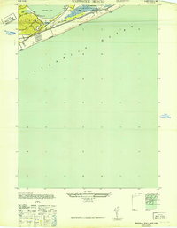
1947 Map of Napeague Beach
USGS Topo · Published 1947About this map
The narrow, windswept stretch of Long Island known as Napeague Beach is captured here just after the war, showing the critical maritime and rail infrastructure that defined the South Fork. The shoreline is dominated by federal installations, including the Napeague CG Sta and the Amagansett LSS Compass Station, reflecting the area's strategic importance for coastal navigation and defense. Inland, the community of Promised Land sits along the northern edge near Napeague Harbor, tied to the rest of the island by the Long Island (Montauk Division) railroad and the appropriately named Lighting Highway. Small landings like Abrams Ldg and Fresh Pond Ldg suggest a landscape where water travel was still integrated with the local economy. The map provides a look at East Hampton's eastern reaches before mid-century development transformed the dunes into a resort destination.
Find a feature on this map
20 named features on this map. Tap any name to fly to it.
Don’t see what you’re looking for? This feature index may not catch every label — zoom into the map to look around manually.
Map Details
Editions of this 1947 Napeague Beach Map
This is the sole edition of this map. No revisions or reprints were ever made.
Other maps of this area

1903 · Gardiners Island
USGS Topo · 1:62,500

1904 · Easthampton
USGS Topo · 1:62,500

1904 · Gardiners Island
USGS Topo · 1:62,500

1904 · Montauk
USGS Topo · 1:62,500

1921 · Gardiners Island
USGS Topo · 1:62,500

1921 · Easthampton
USGS Topo · 1:62,500
1942 · Montauk Point
USGS Topo · 1:24,000

1942 · Block Island
USGS Topo · 1:125,000

1943 · Gardiners Island East
USGS Topo · 1:24,000

1944 · Gardiners Island West
USGS Topo · 1:24,000
Featured Places
- East Hampton, NY
- Montauk, East Hampton
- Amagansett, East Hampton
- Napeague, East Hampton
- Devon, Amagansett