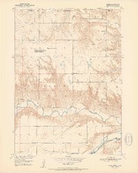
1951 Map of Naper
USGS Topo · Published 1951About this map
Naper stands as a central settlement just south of the South Dakota Nebraska border, positioned in a landscape defined by its river systems and rural school districts. This 1951 survey reveals a high density of local educational sites serving the ranching community, including Mt Zion Sch, Sunnyside Sch, and Basin Sch. The topography transitions from the high ground of the Basin region toward the winding path of the Keya Paha River and the Niobrara River further south. Local landmarks like the Knoll Crest Cem and White Horse Ranch provide specific points of reference for genealogists. The map also records the jurisdictional boundaries of Gregory and Boyd Counties and Boyd and Holt Counties, reflecting the complex administrative geography of the era.
Find a feature on this map
17 named features on this map. Tap any name to fly to it.
Don’t see what you’re looking for? This feature index may not catch every label — zoom into the map to look around manually.
Map Details
Editions of this 1951 Naper Map
2 editions found
Other maps of this area

1951 · Butte NW
USGS Topo · 1:24,000

1951 · Naper
USGS Topo · 1:24,000

1951 · Butte SW
USGS Topo · 1:24,000

1951 · Dustin
USGS Topo · 1:24,000

1951 · Naper SW
USGS Topo · 1:24,000

1955 · Mitchell
USGS Topo · 1:250,000

1955 · O'Neill
USGS Topo · 1:250,000

1959 · O'Neill
USGS Topo · 1:250,000

1959 · Mitchell
USGS Topo · 1:250,000

1964 · St. Charles
USGS Topo · 1:24,000