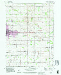
1992 Map of Nappanee East
USGS Topo · Published 1995About this map
Nappanee anchors the northwestern corner of this landscape, where the Grand Army of the Republic Highway cuts across the divide between Elkhart and Kosciusko Counties. The area is defined by a dense network of water management features like Wisler Ditch and Fisher-Gordon Ditch, essential to the agricultural productivity of Union and Jackson townships. Small rural centers such as Gravelton and Hastings appear as quiet clusters of settlement, often centered around community landmarks like the Township Sch or the Brumbaugh Cem. Numerous country houses of worship are scattered across the grid, including Wisler Ch, Union Center Ch, and the isolated Island Chapel in the south. The mapping revisions from the early 1990s show the expansion of the city limits near Stauffer Park, juxtaposed against the enduring rural character of the Turkey Creek drainage.
Find a feature on this map
46 named features on this map. Tap any name to fly to it.
Don’t see what you’re looking for? This feature index may not catch every label — zoom into the map to look around manually.
Map Details
Editions of this 1992 Nappanee East Map
This is the sole edition of this map. No revisions or reprints were ever made.
Other maps of this area

1950 · Leesburg
USGS Topo · 1:24,000

1951 · Milford
USGS Topo · 1:24,000

1953 · Fort Wayne
USGS Topo · 1:250,000

1953 · Chicago
USGS Topo · 1:250,000

1956 · Fort Wayne
USGS Topo · 1:250,000

1957 · Chicago
USGS Topo · 1:250,000

1958 · Nappanee West
USGS Topo · 1:24,000

1958 · Nappanee East
USGS Topo · 1:24,000

1958 · Bourbon
USGS Topo · 1:24,000

1959 · Atwood
USGS Topo · 1:24,000