1950 Map of Nashua
USGS Topo · Published 1950About this map
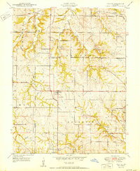
The small settlements of Nashua and Gashland anchor this mid-century survey along the border of Platte and Clay Counties. The landscape is defined by an intricate network of rural schoolhouses, including Lone Star School, Martin School, and Woods School, which served the farming communities spread across the townships of May, Gallatin, and Platte. This distribution of one-room schools suggests a stable, decentralized agricultural population just before suburban expansion reached these northern reaches of the Kansas City region.
Find a feature on this map
25 named features on this map. Tap any name to fly to it.
Don’t see what you’re looking for? This feature index may not catch every label — zoom into the map to look around manually.
Map Details
Editions of this 1950 Nashua Map
This is the sole edition of this map. No revisions or reprints were ever made.
Other maps of this area

1890 · Kansas City
USGS Topo · 1:125,000

1894 · Kansas City
USGS Topo · 1:125,000

1894 · Independence
USGS Topo · 1:125,000

1914 · Smithville
USGS Topo · 1:62,500

1935 · North Kansas City
USGS Topo · 1:24,000

1935 · Liberty
USGS Topo · 1:24,000

1936 · Kearney
USGS Topo · 1:48,000

1940 · Liberty
USGS Topo · 1:31,680

1940 · North Kansas City
USGS Topo · 1:31,680

1942 · Kearney
USGS Topo · 1:62,500