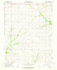
1962 Map of Nashville
USGS Topo · Published 1963About this map
Nashville anchors the southwest corner of this Barton County landscape, which is defined by a dense network of local education and faith centers during the early 1960s. Rural life is meticulously documented through family and community landmarks such as Pierce Cem and the Apostolic Christian Ch. The placement of Union Sch, Pleasant View Sch, North Star Sch, and Duval Sch indicates a distributed population pattern across the townships of Central, Nashville, and North Fork. A notable industrial presence appears in the far northwest, where a Strip Mine marks the edge of the terrain near the state line. Waterways like the West Fork, Little North Fork, and Dry Creek meander through the agricultural sections, providing the primary drainage for this pocket of Southwest Missouri.
Find a feature on this map
15 named features on this map. Tap any name to fly to it.
Don’t see what you’re looking for? This feature index may not catch every label — zoom into the map to look around manually.
Map Details
Editions of this 1962 Nashville Map
This is the sole edition of this map. No revisions or reprints were ever made.
Other maps of this area

1884 · Fort Scott
USGS Topo · 1:125,000

1886 · Nevada
USGS Topo · 1:125,000

1886 · Joplin
USGS Topo · 1:125,000

1886 · Fort Scott
USGS Topo · 1:125,000

1886 · Carthage
USGS Topo · 1:125,000

1893 · Fort Scott
USGS Topo · 1:125,000

1894 · Nevada
USGS Topo · 1:125,000

1894 · Joplin
USGS Topo · 1:125,000

1894 · Carthage
USGS Topo · 1:125,000

1945 · Pittsburg
USGS Topo · 1:62,500