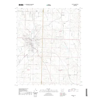
2020 Map of Nashville
USGS Topo · Published 2020About this map
Nashville serves as a significant regional hub near the junction of Howard and Hempstead counties, anchored by the Howard County Courthouse. The landscape is defined by the winding course of Mine Cr and its tributaries, including Brushy Cr and Dodson Cr, which carve through the terrain south of Lake Nickels. Transportation infrastructure is a mix of state routes and county roads like State Hwy 980 and Old Airport Rd, reflecting the area's development around the Howard County Airport. Smaller rural communities such as Bingen, North Bingen, and Clow are scattered across the eastern sections of the quadrangle, connected by an intricate network of local roads. Genealogists will find interest in the documented locations of the Nashville Cem and the more remote Cummings Cem, which provide clues to the settlement patterns and family histories of this Southwest Arkansas corridor.
Find a feature on this map
129 named features on this map. Tap any name to fly to it.
Don’t see what you’re looking for? This feature index may not catch every label — zoom into the map to look around manually.
Map Details
Editions of this 2020 Nashville Map
This is the sole edition of this map. No revisions or reprints were ever made.
Other maps of this area

1906 · Caddo Gap
USGS Topo · 1:125,000

1951 · Mineral Springs South
USGS Topo · 1:24,000

1951 · Columbus
USGS Topo · 1:24,000

1951 · Mineral Springs North
USGS Topo · 1:24,000

1951 · Nashville
USGS Topo · 1:24,000

1951 · Washington
USGS Topo · 1:24,000

1951 · McCaskill
USGS Topo · 1:24,000

1953 · El Dorado
USGS Topo · 1:250,000

1955 · Little Rock
USGS Topo · 1:250,000

1956 · Little Rock
USGS Topo · 1:250,000