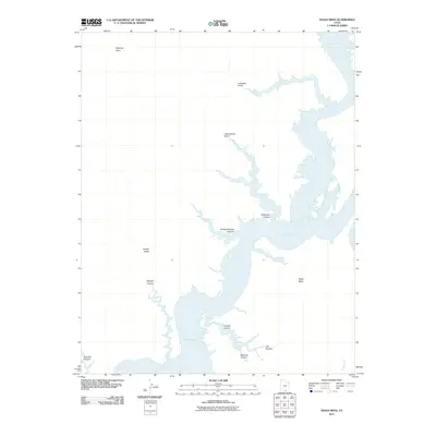
2011 Map of Nasja Mesa
USGS Topo · Published 2011About this map
Lake Powell dominates the eastern half of this landscape, its waters reaching deep into the sandstone architecture of the Colorado Plateau. The intricate shoreline is defined by numerous drowned drainages, where the rising reservoir has transformed former terrestrial features into dramatic aquatic inlets. Prominent among these are Reflection Canyon and Hidden Passage Canyon, which branch westward from the main channel into the surrounding desert. To the west, the topography rises away from the water toward the high ground of Nasja Mesa and the plateau at Fiftymile Point. This 2011 survey captures the complex boundary between the reservoir and the natural canyon systems, documenting the extent of numerous smaller canyons such as Anasazi Canyon and Twilight Canyon before they descend into the lake's fingers. The map serves as a detailed record of this intersection between modern water management and the ancient geometry of Navajo Valley.
Find a feature on this map
14 named features on this map. Tap any name to fly to it.
Don’t see what you’re looking for? This feature index may not catch every label — zoom into the map to look around manually.
Map Details
Editions of this 2011 Nasja Mesa Map
This is the sole edition of this map. No revisions or reprints were ever made.
Other maps of this area

1886 · Escalante
USGS Topo · 1:250,000

1886 · Henry Mountains
USGS Topo · 1:250,000

1892 · Henry Mountains
USGS Topo · 1:250,000

1953 · Cummings Mesa
USGS Topo · 1:62,500

1953 · The Rincon
USGS Topo · 1:62,500

1953 · Navajo Mountain
USGS Topo · 1:62,500

1956 · Escalante
USGS Topo · 1:250,000

1960 · Escalante
USGS Topo · 1:250,000
1968 · Sooner Bench
USGS Topo · 1:24,000
1981 · Navajo Mountain
USGS Topo · 1:100,000