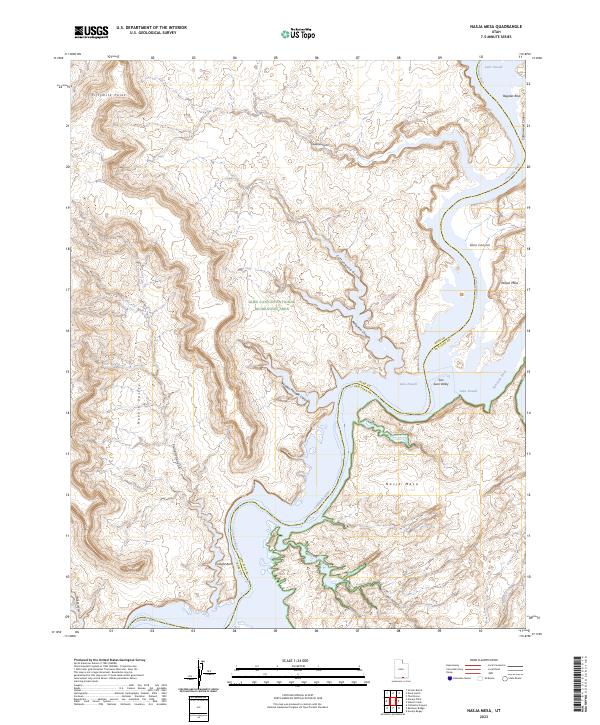
2023 Map of Nasja Mesa
USGS Topo · Published 2023About this map
Lake Powell dominates the landscape of this southern Utah region, where the flooded canyons of the Colorado River meet the San Juan River at their dramatic confluence. The geography is defined by the high, flat-topped Nasja Mesa and the surrounding labyrinth of deep drainages including Reflection Canyon, Anasazi Canyon, and Hidden Passage Canyon. Within the Glen Canyon National Recreation Area, the map documents specific landmarks such as Twilight Arch and Register Rock, providing a detailed view of the modern shoreline as it winds through the prehistoric geology of Glen Canyon. The boundary between Kane and San Juan Counties follows the path of the original river channels, now submerged beneath the fluctuating waters of the reservoir, while terrestrial features like Fifthymile Point and Navajo Valley remain prominent above the water line.
Find a feature on this map
24 named features on this map. Tap any name to fly to it.
Don’t see what you’re looking for? This feature index may not catch every label — zoom into the map to look around manually.
Map Details
Editions of this 2023 Nasja Mesa Map
This is the sole edition of this map. No revisions or reprints were ever made.
Other maps of this area

1886 · Escalante
USGS Topo · 1:250,000

1886 · Henry Mountains
USGS Topo · 1:250,000

1892 · Henry Mountains
USGS Topo · 1:250,000

1953 · Cummings Mesa
USGS Topo · 1:62,500

1953 · The Rincon
USGS Topo · 1:62,500

1953 · Navajo Mountain
USGS Topo · 1:62,500

1956 · Escalante
USGS Topo · 1:250,000

1960 · Escalante
USGS Topo · 1:250,000
1968 · Sooner Bench
USGS Topo · 1:24,000
1981 · Navajo Mountain
USGS Topo · 1:100,000