
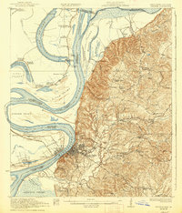
1959 Map of Natchez
USGS Topo · Published 1959About this map
The Mississippi River defines the western reaches of this 1959 landscape, winding through a complex system of oxbow lakes and bottomlands like Lake Concordia and Lake Bruin. East of the river bluffs, the terrain transitions into the dense timberlands of the Homochitto National Forest, where the Homochitto River and its tributaries cut through the rolling Pine Hills. The region is a study in mid-century connectivity, anchored by the rail hubs of Brookhaven and McComb along the Illinois Central RR.
Find a feature on this map
231 named features on this map. Tap any name to fly to it.
Don’t see what you’re looking for? This feature index may not catch every label — zoom into the map to look around manually.
Map Details
Editions of this 1959 Natchez Map
This is the sole edition of this map. No revisions or reprints were ever made.
Other maps of this area

1903 · Jackson
USGS Topo · 1:125,000

1906 · Bayou Sara
USGS Topo · 1:125,000

1906 · Florence
USGS Topo · 1:62,500

1908 · Florence
USGS Topo · 1:62,500

1909 · Delta Bridge
USGS Topo · 1:24,000

1909 · Sycamore Landing
USGS Topo · 1:24,000

1909 · Lake Bruen
USGS Topo · 1:24,000
1909 · Vidalia
USGS Topo · 1:24,000

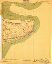
1921 · Natchez
USGS Topo · 1:48,000
1922 · Natchez
USGS Topo · 1:62,500