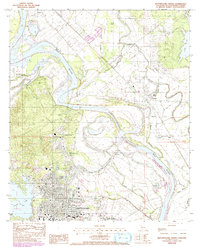
1983 Map of Natchitoches North
USGS Topo · Published 1992About this map
Natchitoches serves as the focal point of this northern Parish survey, situated where the Red River meanders through a landscape defined by an intricate network of bayous and lakes. The historic settlement of Grand Ecore occupies the high ground overlooking the river, a position that historically controlled traffic on these waterways. To the south, the extensive campus of Northwestern State Univ and St Marys Sch anchor the town, while Cane River Lake and Sibley Lake frame the developed areas.
Find a feature on this map
36 named features on this map. Tap any name to fly to it.
Don’t see what you’re looking for? This feature index may not catch every label — zoom into the map to look around manually.
Map Details
Editions of this 1983 Natchitoches North Map
2 editions found
Other maps of this area

1935 · Hagewood
USGS Topo · 1:31,680

1937 · Campti NE
USGS Topo · 1:31,680

1937 · Bermuda
USGS Topo · 1:31,680

1937 · Campti SE
USGS Topo · 1:31,680

1937 · Campti NW
USGS Topo · 1:31,680

1937 · Montgomery
USGS Topo · 1:62,500

1937 · Campti SW
USGS Topo · 1:31,680

1942 · Montgomery
USGS Topo · 1:62,500

1943 · Provencal
USGS Topo · 1:62,500

1944 · Campti
USGS Topo · 1:62,500