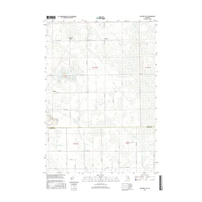
2017 Map of National City
USGS Topo · Published 2017About this map
National City and the neighboring settlements of McIvor and Turtle anchor this landscape along the border of Iosco and Arenac Counties. The area is defined by a complex network of waterways and drainage systems, where the Au Gres River and its branches, including the E Br Au Gres River and W Br Au Gres River, wind through low-lying terrain. Extensive wetland areas like Messer Swamp and Alabaster Swamp dominate the northeastern and eastern portions of the map, illustrating the persistent hydrologic character of this part of Michigan.
Find a feature on this map
60 named features on this map. Tap any name to fly to it.
Don’t see what you’re looking for? This feature index may not catch every label — zoom into the map to look around manually.
Map Details
Editions of this 2017 National City Map
This is the sole edition of this map. No revisions or reprints were ever made.
Other maps of this area

1954 · Tawas City
USGS Topo · 1:250,000

1958 · Tawas City
USGS Topo · 1:250,000

1959 · Tawas City
USGS Topo · 1:62,500

1966 · Point Lookout
USGS Topo · 1:24,000

1966 · Au Gres
USGS Topo · 1:24,000

1966 · Alabaster
USGS Topo · 1:24,000

1966 · National City
USGS Topo · 1:24,000

1968 · Whittemore
USGS Topo · 1:24,000
1968 · Omer
USGS Topo · 1:24,000

1968 · Hale SE
USGS Topo · 1:24,000