2023 Map of Natural Bridge
USGS Topo · Published 2023About this map
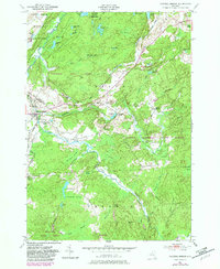
Natural Bridge and the Diana Center settlement anchor this terrain at the border of Jefferson and Lewis counties. The landscape is defined by the winding course of the Indian River, which meanders through the Indian River Flats and the expansive Punky Swamp. Local history is preserved at Hillside Cem and Blanchard Cem, while the industrial and agricultural heritage of the region is reflected in names like Steam Mill Pond, Quarry Pond, and Factory Rd. A dense network of local roads such as Aldrich Settlement Rd and Old State Rd connects these scattered landmarks across a mosaic of marshes and wetlands, including Black Ash Swamp and Blanchard Swamp. The hydrology here is remarkably intricate, with numerous small bodies of water like Doherty Pond and Little Rocks Ponds feeding into Blanchard Creek and Weatherhead Creek.
Find a feature on this map
69 named features on this map. Tap any name to fly to it.
Don’t see what you’re looking for? This feature index may not catch every label — zoom into the map to look around manually.
Map Details
Editions of this 2023 Natural Bridge Map
This is the sole edition of this map. No revisions or reprints were ever made.