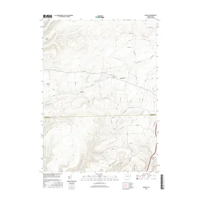
2016 Map of Nauvoo
USGS Topo · Published 2016About this map
Nauvoo and Hartsfield sit along the winding rural corridors of northern Pennsylvania, where the landscape is defined by the sharp transition between elevated plateaus and deep stream valleys. This 2016 survey documents a region where local geography is tied to historic landmarks like the Buttonwood Covered Bridge and the Salem Lutheran Cem, which serve as focal points for the surrounding community. The terrain is marked by prominent ridges such as Hickory Ridge and the heights of Sugar Hill, while the drainage network includes Blacks Creek, Little Fall Cr, and Zimmerman Cr. The map reveals a spiderweb of secondary roads named for early families and local industries, including Milk Plant Rd, Snyder Rd, and Bower Rd, illustrating the enduring pattern of remote settlements like Plank and the rugged topography of Bear Hollow.
Find a feature on this map
62 named features on this map. Tap any name to fly to it.
Don’t see what you’re looking for? This feature index may not catch every label — zoom into the map to look around manually.
Map Details
Editions of this 2016 Nauvoo Map
This is the sole edition of this map. No revisions or reprints were ever made.
Other maps of this area

1921 · Trout Run
USGS Topo · 1:62,500

1923 · Trout Run
USGS Topo · 1:62,500

1925 · Blossburg
USGS Topo · 1:62,500

1927 · Blossburg
USGS Topo · 1:62,500

1937 · Waterville
USGS Topo · 1:48,000

1943 · Waterville
USGS Topo · 1:62,500

1944 · Blossburg
USGS Topo · 1:62,500

1944 · Trout Run
USGS Topo · 1:62,500

1946 · Antrim
USGS Topo · 1:62,500

1946 · Antrim
USGS Topo · 1:24,000
Featured Places
- Morris Township, PA
- Duncan Township, PA
- Pine Township, PA
- Nauvoo, Liberty Township
- Hartsfield, Liberty Township