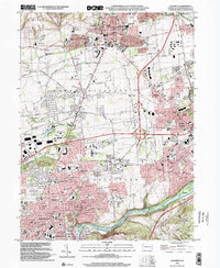
1999 Map of Nazareth
USGS Topo · Published 2002About this map
The borough of Nazareth anchors this Lehigh Valley survey, revealing a landscape defined by Moravian history and industrial evolution. Established landmarks like the Moravian Ch and the historic site of Christian Springs stand alongside 20th-century developments, including the Nazareth Speedway and large-scale healthcare facilities like the Gracedale County Home. The southern portion of the sheet is marked by the industrial corridor of the Lehigh River and the parallel Lehigh Canal, where settlements such as Steel City and Freemansburg developed near the massive steel-making infrastructure of Bethlehem.
Find a feature on this map
116 named features on this map. Tap any name to fly to it.
Don’t see what you’re looking for? This feature index may not catch every label — zoom into the map to look around manually.
Map Details
Editions of this 1999 Nazareth Map
This is the sole edition of this map. No revisions or reprints were ever made.
Other maps of this area

1890 · Easton
USGS Topo · 1:62,500

1891 · Easton
USGS Topo · 1:62,500

1891 · Delaware Water Gap
USGS Topo · 1:62,500

1893 · Delaware Water Gap
USGS Topo · 1:62,500

1894 · Allentown
USGS Topo · 1:62,500

1914 · Wind Gap
USGS Topo · 1:62,500

1916 · Wind Gap
USGS Topo · 1:62,500

1932 · Easton
USGS Topo · 1:62,500

1936 · Delaware Water Gap
USGS Topo · 1:48,000

1939 · Allentown
USGS Topo · 1:62,500