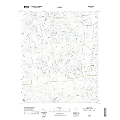
2020 Map of Nebo
USGS Topo · Published 2020About this map
Nebo and Sudie sit at the center of this Paulding and Douglas County landscape, where suburban growth meets the traditional rural markers of North Georgia. The area is defined by a dense network of residential corridors and numerous small impoundments such as Hatcher Lake, Williams Lake, and Lake Romona. Local history is anchored by several long-standing burial grounds including New Harmony Cem and Nebo Cem, while the industrial and transportation footprint is marked by Pinewood Airport near the center of the sheet. In the southern portion, the terrain shifts toward Cedar Mtn and the developing outskirts of Douglasville and Villa Rica. Drainage patterns like Sweetwater Cr and its various branches, including Gothards Cr and Waterfall Br, illustrate the complex hydrology that influenced early settlement and modern land division in this part of the Piedmont.
Find a feature on this map
272 named features on this map. Tap any name to fly to it.
Don’t see what you’re looking for? This feature index may not catch every label — zoom into the map to look around manually.
Map Details
Editions of this 2020 Nebo Map
This is the sole edition of this map. No revisions or reprints were ever made.
Other maps of this area

1891 · Marietta
USGS Topo · 1:125,000

1895 · Marietta
USGS Topo · 1:125,000

1897 · Marietta
USGS Topo · 1:125,000

1901 · Marietta
USGS Topo · 1:125,000

1953 · Atlanta
USGS Topo · 1:250,000

1954 · Campbellton
USGS Topo · 1:24,000
1954 · Lost Mountain
USGS Topo · 1:24,000

1954 · Austell
USGS Topo · 1:24,000

1957 · Atlanta
USGS Topo · 1:250,000

1958 · Atlanta
USGS Topo · 1:250,000