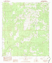
1982 Map of Necaise
USGS Topo · Published 1983About this map
Small rural communities and timber-lined waterways define this coastal Mississippi interior during the early 1980s. The settlement of Necaise serves as a central hub, accompanied by the nearby Necaise Cem and the Necaise Lookout Tower. This landscape is marked by a network of Baptist and community churches including Crane Creek Ch, Shiloh Ch, and Victory Ch, reflecting the deep-rooted local history of Hancock County.
Find a feature on this map
24 named features on this map. Tap any name to fly to it.
Don’t see what you’re looking for? This feature index may not catch every label — zoom into the map to look around manually.
Map Details
Editions of this 1982 Necaise Map
This is the sole edition of this map. No revisions or reprints were ever made.
Other maps of this area

1914 · Nicholson
USGS Topo · 1:62,500

1921 · Nicholson
USGS Topo · 1:62,500

1953 · Mobile
USGS Topo · 1:250,000

1955 · Savannah
USGS Topo · 1:62,500

1956 · Vidalia
USGS Topo · 1:24,000

1957 · Mobile
USGS Topo · 1:250,000

1957 · Dead Tiger Creek
USGS Topo · 1:24,000

1958 · Picayune
USGS Topo · 1:62,500
1959 · Kiln
USGS Topo · 1:24,000
1959 · Nicholson
USGS Topo · 1:62,500