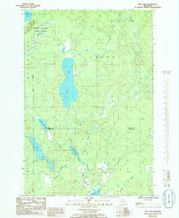
1985 Map of Ned Lake
USGS Topo · Published 1986About this map
Copper Country State Forest dominates this northern Michigan landscape, where the border of Baraga County and Iron County cuts through a dense network of glacial lakes and river systems. The central feature is the elongated basin of Ned Lake, which feeds into the Ned Lake Creek and eventually the Net River. To the south, the terrain transitions into the Covington and Hematite areas, marked by the winding courses of the Fence River and West Branch. The map reveals a remote wilderness punctuated only by a single Gravel Pit, suggesting the primary land use remains timber and conservation within the Spurr and Hematite townships. Water remains the defining element, from the broad expanse of Shank Lake to the marshy stretches of Flanigan Slough.
Find a feature on this map
22 named features on this map. Tap any name to fly to it.
Don’t see what you’re looking for? This feature index may not catch every label — zoom into the map to look around manually.
Map Details
Editions of this 1985 Ned Lake Map
This is the sole edition of this map. No revisions or reprints were ever made.
Other maps of this area

1895 · Ned Lake
USGS Topo · 1:62,500

1899 · Witbeck
USGS Topo · 1:62,500

1955 · Ned Lake
USGS Topo · 1:62,500

1955 · Herman
USGS Topo · 1:62,500

1955 · Witch Lake
USGS Topo · 1:62,500

1956 · Three Lakes
USGS Topo · 1:24,000

1956 · Michigamme
USGS Topo · 1:62,500

1958 · Iron River
USGS Topo · 1:250,000

1960 · Iron River
USGS Topo · 1:250,000

1961 · Iron River
USGS Topo · 1:250,000
Featured Places
- Hematite Township, MI
- Covington Township, MI
- Crystal Falls Township, MI
- Spurr Township, MI
- Iron County, MI