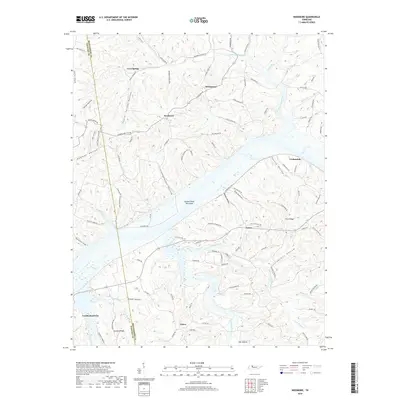
2019 Map of Needmore
USGS Topo · Published 2019About this map
Cumberland City and the surrounding river bottomlands define this portion of the Stewart and Montgomery county line. The landscape is characterized by a dense network of hollows and ridges, such as Isaiah Hollow, Fessey Hollow, and Gunson Ridge, which guide the drainage of Blooming Grove Creek and the East Fork Yellow Creek. The map documents numerous small settlements including Needmore, Stringtown, and Corbandale, connected by a web of rural routes like Lylewood RD and Cumberland City RD. A notable river feature, Yellow Creek Tow Head, sits in the channel where the water systems converge. Local history and genealogy interest is found in specific landmarks like Bowers Cemetery Rd and named terrain features like Jackass Hollow and Schuff Hollow, reflecting the traditional naming conventions of this Tennessee river country.
Find a feature on this map
103 named features on this map. Tap any name to fly to it.
Don’t see what you’re looking for? This feature index may not catch every label — zoom into the map to look around manually.
Map Details
Editions of this 2019 Needmore Map
This is the sole edition of this map. No revisions or reprints were ever made.
Other maps of this area

1931 · Erin
USGS Topo · 1:62,500

1936 · Tantrough Hollow
USGS Topo · 1:24,000

1944 · Clarksville
USGS Topo · 1:50,000

1951 · New Providence
USGS Topo · 1:24,000

1951 · Indian Mound
USGS Topo · 1:24,000

1951 · Woodlawn
USGS Topo · 1:24,000

1956 · Nashville
USGS Topo · 1:250,000

1957 · New Providence
USGS Topo · 1:24,000
1957 · Indian Mound
USGS Topo · 1:24,000
1957 · Woodlawn
USGS Topo · 1:24,000