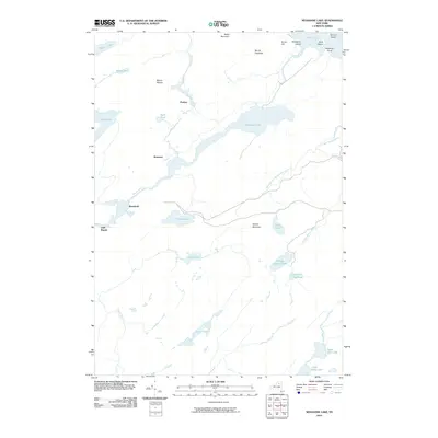
2010 Map of Nehasane Lake
USGS Topo · Published 2010About this map
Nehasane Lake and its surrounding wilderness define this section of the Adirondacks, where the Beaver River winds through a complex network of glacial ponds and wetlands. This 2010 survey shows the remote character of the landscape, punctuated by small settlements like Little Rapids, Brandreth, and Partlow that serve as nodes in this secluded region. The area's hydrology is remarkably intricate, featuring the meandering Alder Creek and numerous distinct water bodies such as Lake Lila, Thayer Lake, and the evocative Terror Lake. Prominent elevations like Mount Electra and Webb Mountain provide significant vertical relief against the sprawling lowlands and brooks, including the North Branch Shingle Shanty Brook. This map serves as a vital record of the interior forest and waterway connections before modern development could further alter these traditional Adirondack corridors.
Find a feature on this map
32 named features on this map. Tap any name to fly to it.
Don’t see what you’re looking for? This feature index may not catch every label — zoom into the map to look around manually.
Map Details
Editions of this 2010 Nehasane Lake Map
This is the sole edition of this map. No revisions or reprints were ever made.
Other maps of this area

1903 · Big Moose
USGS Topo · 1:62,500

1903 · Raquette Lake
USGS Topo · 1:62,500

1907 · Tupper Lake
USGS Topo · 1:62,500

1919 · Cranberry Lake
USGS Topo · 1:62,500

1921 · Cranberry Lake
USGS Topo · 1:62,500

1931 · Cranberry Lake
USGS Topo · 1:62,500

1948 · Ogdensburg
USGS Topo · 1:250,000

1950 · Utica
USGS Topo · 1:250,000

1951 · Ogdensburg
USGS Topo · 1:250,000

1953 · Ogdensburg
USGS Topo · 1:250,000