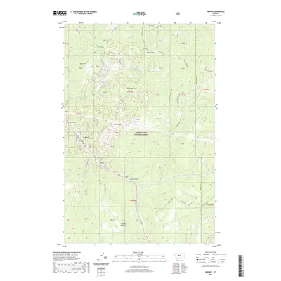
2020 Map of Neihart
USGS Topo · Published 2020About this map
Neihart sits deep within the Lewis & Clark National Forest, centered along the corridor formed by Belt Creek as it carves through the Little Belt Mountains. The settlement's street grid, including Main Street and Wells Street, reflects its long association with the surrounding canyon floor. The landscape is characterized by high-elevation landmarks such as Neihart Baldy and the elongated Pioneer Ridge, with numerous drainages like S Fork Hoover Creek and Chamberlain Creek feeding the local watershed. Evidence of the area's industrial past survives in place names like Narrow Gauge Gulch and Compromise Gulch, suggesting a history of narrow-gauge rail transport and mining claims common to this mountain district. Higher elevations feature recreational landmarks like Memorial Falls and Hidden Canyon, while the Neihart Reservoir serves as a vital water resource for the mountain community.
Find a feature on this map
51 named features on this map. Tap any name to fly to it.
Don’t see what you’re looking for? This feature index may not catch every label — zoom into the map to look around manually.
Map Details
Editions of this 2020 Neihart Map
This is the sole edition of this map. No revisions or reprints were ever made.
Other maps of this area

1886 · Little Belt Mts.
USGS Topo · 1:250,000

1890 · Fort Benton
USGS Topo · 1:250,000

1892 · Fort Benton
USGS Topo · 1:250,000

1894 · Little Belt Mts.
USGS Topo · 1:250,000

1897 · Fort Benton
USGS Topo · 1:250,000

1897 · Little Belt Mts.
USGS Topo · 1:250,000

1898 · Little Belt Mts.
USGS Topo · 1:250,000

1902 · Little Belt Mts.
USGS Topo · 1:250,000

1948 · White Sulphur Springs
USGS Topo · 1:250,000

1954 · Great Falls
USGS Topo · 1:250,000