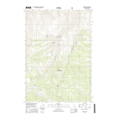
2017 Map of Neil Gulch
USGS Topo · Published 2017About this map
Payette National Forest dominates this section of Washington County, defined by high-elevation ridges and the complex drainage systems of the Brownlee Creek watershed. High points like Sturgill Peak and Sturgill Ridge anchor the southern terrain, while distinct glaciated features such as Stickney Glacier and Sheep Camp Glacier are noted further north. This modern survey illustrates the specialized nomenclature of the backcountry, from the high saddles like Benton Saddle and Telephone Saddle to functional local landmarks like the Tool Cache. The map reveals a landscape used for seasonal grazing and forestry, evidenced by clearings such as Pine Grass Flat and Coffee Flat. A network of Forest Service routes, including the Middle Fork Brownlee Creek Rd, provides the primary access through these high-relief gulches and canyons.
Find a feature on this map
45 named features on this map. Tap any name to fly to it.
Don’t see what you’re looking for? This feature index may not catch every label — zoom into the map to look around manually.
Map Details
Editions of this 2017 Neil Gulch Map
This is the sole edition of this map. No revisions or reprints were ever made.
Other maps of this area

1915 · Pine
USGS Topo · 1:125,000

1955 · Baker
USGS Topo · 1:250,000

1957 · Halfway
USGS Topo · 1:62,500

1957 · Copperfield
USGS Topo · 1:62,500

1957 · Sturgill Peak
USGS Topo · 1:62,500

1957 · Mineral
USGS Topo · 1:62,500

1959 · Baker
USGS Topo · 1:250,000

1980 · McCall
USGS Topo · 1:100,000

1981 · Baker
USGS Topo · 1:100,000
1987 · Brownlee Dam
USGS Topo · 1:24,000