
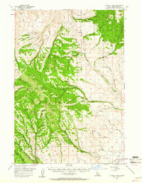
1957 Map of Sturgill Peak
USGS Topo · Published 1959About this map
Sturgill Peak and Hitt Peak anchor the high elevations of the Hitt Mountains in the late 1950s, a landscape defined by the administrative and utilitarian infrastructure of the Payette National Forest. This survey documents a working wilderness where the Brownlee Ranger Station and Mann Creek Guard Station served as key outposts for forest management. The presence of a Tool Cache deep in the hills and a Jeep Trail suggests the era's reliance on rugged access for conservation and fire monitoring.
Find a feature on this map
62 named features on this map. Tap any name to fly to it.
Don’t see what you’re looking for? This feature index may not catch every label — zoom into the map to look around manually.
Map Details
Editions of this 1957 Sturgill Peak Map
2 editions found
Other maps of this area

1897 · Weiser
USGS Topo · 1:125,000

1915 · Pine
USGS Topo · 1:125,000

1952 · Olds Ferry
USGS Topo · 1:62,500

1953 · Mann Creek
USGS Topo · 1:62,500

1955 · Baker
USGS Topo · 1:250,000

1957 · Halfway
USGS Topo · 1:62,500

1957 · Cambridge
USGS Topo · 1:62,500

1957 · Crane Creek Reservoir
USGS Topo · 1:62,500

1957 · Copperfield
USGS Topo · 1:62,500

1957 · Hornet
USGS Topo · 1:62,500