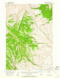
1957 Map of Sturgill Peak
USGS Topo · Published 1961About this map
Sturgill Peak stands as the central high point of this mid-century survey, overlooking the high ridges and deep canyons of the Payette National Forest. This section of the Hitt Mountains is defined by a dense network of watercourses including Brownlee Creek, Pine Creek, and Middie Brownlee Creek, which drain toward the Snake River drainage. In the more open eastern sections, the landscape transitions into the Shoe Peg Valley, where traces of early development are visible in the Advent School and a Cemetery.
Find a feature on this map
64 named features on this map. Tap any name to fly to it.
Don’t see what you’re looking for? This feature index may not catch every label — zoom into the map to look around manually.
Map Details
Editions of this 1957 Sturgill Peak Map
2 editions found

Other maps of this area

1897 · Weiser
USGS Topo · 1:125,000

1915 · Pine
USGS Topo · 1:125,000

1952 · Olds Ferry
USGS Topo · 1:62,500

1953 · Mann Creek
USGS Topo · 1:62,500

1955 · Baker
USGS Topo · 1:250,000

1957 · Halfway
USGS Topo · 1:62,500

1957 · Cambridge
USGS Topo · 1:62,500

1957 · Crane Creek Reservoir
USGS Topo · 1:62,500

1957 · Copperfield
USGS Topo · 1:62,500

1957 · Hornet
USGS Topo · 1:62,500