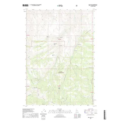
2020 Map of Neil Gulch
USGS Topo · Published 2020About this map
Payette National Forest dominates this section of Washington County, defined by high-elevation ridges and deep drainages. The landscape is punctuated by the presence of Stickney Glacier and Sheep Camp Glacier, marking the high points of the terrain near Sturgill Peak. The naming of features like Wash Pan Mill Creek and Neil Gulch suggests a history of resource extraction or early homesteading in these remote gulches. High-country travel is facilitated by multiple saddles and flats, such as Benton Saddle, Telephone Saddle, and Pine Grass Flat. This 2020 record of the region captures the modern forest management infrastructure, including Natl Forest Develop Road 027 Rd, which provides access to the headwaters of W Brownlee Cr and Cottonwood Cr. The map preserves the specific locations of isolated water sources like Cottonwood Creek-Box Spring and Arrowhead Spring.
Find a feature on this map
49 named features on this map. Tap any name to fly to it.
Don’t see what you’re looking for? This feature index may not catch every label — zoom into the map to look around manually.
Map Details
Editions of this 2020 Neil Gulch Map
This is the sole edition of this map. No revisions or reprints were ever made.
Other maps of this area

1915 · Pine
USGS Topo · 1:125,000

1955 · Baker
USGS Topo · 1:250,000

1957 · Halfway
USGS Topo · 1:62,500

1957 · Copperfield
USGS Topo · 1:62,500

1957 · Sturgill Peak
USGS Topo · 1:62,500

1957 · Mineral
USGS Topo · 1:62,500

1959 · Baker
USGS Topo · 1:250,000

1980 · McCall
USGS Topo · 1:100,000

1981 · Baker
USGS Topo · 1:100,000
1987 · Brownlee Dam
USGS Topo · 1:24,000