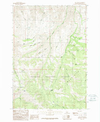
1987 Map of Neil Gulch
USGS Topo · Published 1987About this map
Payette National Forest dominates this high-altitude landscape in the Hitt Mountains, where a complex network of drainages and gulches defines the western Idaho backcountry during the late 1980s. The terrain is marked by numerous water sources critical for livestock and wildlife, such as Box Spring, Arrowhead Spring, and Tribe Spring, which are scattered throughout the steep slopes and ridges. Significant landmarks like Telephone Saddle and Benton Saddle provide passage between the deep incisions of Stickney Gulch and Sheep Camp Gulch. This survey reveals a landscape primarily dedicated to resource management and conservation, with a notable Gravel Pit and a series of pack trails and 4WD tracks serving as the primary infrastructure for navigating the high-relief environment. Large seasonal watercourses, including Brownlee Creek and Cottonwood Creek, draw from the higher elevations down toward the surrounding basins.
Find a feature on this map
29 named features on this map. Tap any name to fly to it.
Don’t see what you’re looking for? This feature index may not catch every label — zoom into the map to look around manually.
Map Details
Editions of this 1987 Neil Gulch Map
This is the sole edition of this map. No revisions or reprints were ever made.
Other maps of this area

1915 · Pine
USGS Topo · 1:125,000

1955 · Baker
USGS Topo · 1:250,000

1957 · Halfway
USGS Topo · 1:62,500

1957 · Copperfield
USGS Topo · 1:62,500

1957 · Sturgill Peak
USGS Topo · 1:62,500

1957 · Mineral
USGS Topo · 1:62,500

1959 · Baker
USGS Topo · 1:250,000

1980 · McCall
USGS Topo · 1:100,000

1981 · Baker
USGS Topo · 1:100,000
1987 · Brownlee Dam
USGS Topo · 1:24,000