
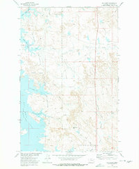
1973 Map of Nelson Creek Bay
USGS Topo · Published 1977About this map
Charles M Russell National Wildlife Range dominates this landscape along the eastern edge of the Dry Arm of Fort Peck Lake. The 1973 survey illustrates a rugged terrain defined by extensive coulees and points extending into the reservoir waters, such as Jacks Point, Stubby Point, and the distinct South Twitchel Point. This area of McCone County shows a sparsely populated ranching and wilderness landscape where small family names and landmarks like Nelson and Davis mark the map alongside cattle-country features like Steer Coulee and Foster Coulee. The topography reveals the complex drainage patterns feeding into Nelson Creek Bay and McGuire Creek Bay, with numerous temporary water sources like Carney Springs sustaining the local ecology and livestock within this vast protected range.
Find a feature on this map
35 named features on this map. Tap any name to fly to it.
Don’t see what you’re looking for? This feature index may not catch every label — zoom into the map to look around manually.
Map Details
Editions of this 1973 Nelson Creek Bay Map
This is the sole edition of this map. No revisions or reprints were ever made.
Other maps of this area

1954 · Jordan
USGS Topo · 1:250,000

1956 · Jordan
USGS Topo · 1:250,000

1958 · Jordan
USGS Topo · 1:250,000

1964 · Jordan
USGS Topo · 1:250,000

1967 · Frank Coulee
USGS Topo · 1:24,000

1972 · Short Creek
USGS Topo · 1:24,000

1972 · Ash Creek East
USGS Topo · 1:24,000

1973 · Crow Springs
USGS Topo · 1:24,000

1973 · Rodgers Hall
USGS Topo · 1:24,000
1973 · Bug Creek
USGS Topo · 1:24,000